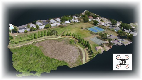
Getting Started with Open Drone Map (ODM)
Getting Started with Open Drone Map (ODM), available at $49.99, has an average rating of 3.8, with 27 lectures, based on 46 reviews, and has 270 subscribers.
You will learn about Download and install Free and Open Source photogrammetry software Create 2D data products with your drone (Orthomosaics and DSMs and DTMs) Create to make 3D data products with your drone (Models and Volume Calculations) Master Photogrammetry techniques from drone photographs This course is ideal for individuals who are Drone pilots who wish to learn 2D and 3D mapping techniques or Those who want to learn drone photogrammetry for free It is particularly useful for Drone pilots who wish to learn 2D and 3D mapping techniques or Those who want to learn drone photogrammetry for free.
Enroll now: Getting Started with Open Drone Map (ODM)
Summary
Title: Getting Started with Open Drone Map (ODM)
Price: $49.99
Average Rating: 3.8
Number of Lectures: 27
Number of Published Lectures: 27
Number of Curriculum Items: 27
Number of Published Curriculum Objects: 27
Original Price: $49.99
Quality Status: approved
Status: Live
What You Will Learn
- Download and install Free and Open Source photogrammetry software
- Create 2D data products with your drone (Orthomosaics and DSMs and DTMs)
- Create to make 3D data products with your drone (Models and Volume Calculations)
- Master Photogrammetry techniques from drone photographs
Who Should Attend
- Drone pilots who wish to learn 2D and 3D mapping techniques
- Those who want to learn drone photogrammetry for free
Target Audiences
- Drone pilots who wish to learn 2D and 3D mapping techniques
- Those who want to learn drone photogrammetry for free
Drones are incredible machines, capable of creating amazingly useful mapping products. By using drone images, one can create detailed maps and models of the earth through a process called Photogrammetry. Essentially, you computer analyzes the same area in multiple images and calculates a 3D model. Because of photogrammetry’s usefulness, it is very expensive. However, there is a better way. A great way to get started with this is downloading and installing Open Drone Map, a free and open source software package available to everyone on the web. This course instructs you on how to:
-
Download and Install Open Drone Map, a free and open source photogrammetry software package
-
Load in photos that you took with your drone
-
Create data products such as Orthophotos, Orthomosaics, Digital Surface Models, Digital Terrain Models, 3D models
-
Take these data products and get them into GIS software for further analysis
Your Instructor has been making digital maps for over 30 years and teaching digital map making techniques at a University in Boston, MA for over 15 years. He has taught countless GIS labs using both ESRI products and, as of late, QGIS software. Around 5 years ago, the drones arrived and have allowed map makers to create high resolution background images of their study areas. As the digital mapping field matures into 3D visualization, drones as data collection machines continue to increase in usefulness.
This course is designed for folks who want to get started in Photogrammetry without having to pony up big bucks for the commercial software. With ODM, you can learn all you want for free. You may graduate up more complicated software at some point if your products start turning a real profit. You may find however that ODM fills all your needs and you’ll never have to pay those high costs.
The course comes with instructions on how to get to many sample data sets as well as written instructions for software installation. With this course you have everything you need to get up and running. Now is the time to level up your drone game!
Course Curriculum
Chapter 1: Introduction
Lecture 1: 1-1 Welcome to Class
Lecture 2: 1-2 What is Open Drone Map?
Lecture 3: 1-3 ODM Versus – A Software Comparison
Chapter 2: Installation and Setup
Lecture 1: 2-1 Installing Open Drome Map from Github for Free
Lecture 2: 2-2 Installing WebODM via the Paid Installer
Lecture 3: 2-3 A Quick Look at the ODM Interface
Lecture 4: 2-4 Sample Datasets for Practice
Lecture 5: 2-5 A Quick 3D Rendering of Bananas
Lecture 6: 2-6 Uploading Drone Photos into ODM
Chapter 3: Photogrammetry Terms and Concepts
Lecture 1: 3-1 Orthophotos and Orthomosaics
Lecture 2: 3-2 Surface and Terrain Models
Lecture 3: 3-3 3D Model Formats
Lecture 4: 3-4 Other Terms to Know
Chapter 4: The WebODM User Interface
Lecture 1: 4-1 Creating Orthos, Plant Health Analysis, Surface Model and Terrain Model
Lecture 2: 4-2 3D Interface – Camera
Lecture 3: 4-3 3D Interface – Textured Models
Lecture 4: 4-4 3D Interface – Appearance
Lecture 5: 4-5 3D Interface – Tools (Measurement, Clipping, Navigation)
Lecture 6: 4-6 3D Interface – Scene Export
Lecture 7: 4-7 3D Interface – Filter and Classification
Lecture 8: 4-8 – A Quick 3D Model Test of a Complicated Building
Chapter 5: Additional Features
Lecture 1: 5-1 Downloading Assets
Lecture 2: 5-2 Tour of a Quality Report
Lecture 3: 5-3 Ground Control Point (GCP) Interface
Lecture 4: 5-4 Cloud Processing with Lightning Network
Lecture 5: 5-5 ODM Community Forum
Lecture 6: 5-6 Using Your Newly Minted Orthos in GIS
Instructors
-
Scott Lussier
Environmental Science Instructor / GIS Expert / Drone Pilot
Rating Distribution
- 1 stars: 4 votes
- 2 stars: 3 votes
- 3 stars: 6 votes
- 4 stars: 14 votes
- 5 stars: 19 votes
Frequently Asked Questions
How long do I have access to the course materials?
You can view and review the lecture materials indefinitely, like an on-demand channel.
Can I take my courses with me wherever I go?
Definitely! If you have an internet connection, courses on Udemy are available on any device at any time. If you don’t have an internet connection, some instructors also let their students download course lectures. That’s up to the instructor though, so make sure you get on their good side!
You may also like
- Top 10 Language Learning Courses to Learn in November 2024
- Top 10 Video Editing Courses to Learn in November 2024
- Top 10 Music Production Courses to Learn in November 2024
- Top 10 Animation Courses to Learn in November 2024
- Top 10 Digital Illustration Courses to Learn in November 2024
- Top 10 Renewable Energy Courses to Learn in November 2024
- Top 10 Sustainable Living Courses to Learn in November 2024
- Top 10 Ethical AI Courses to Learn in November 2024
- Top 10 Cybersecurity Fundamentals Courses to Learn in November 2024
- Top 10 Smart Home Technology Courses to Learn in November 2024
- Top 10 Holistic Health Courses to Learn in November 2024
- Top 10 Nutrition And Diet Planning Courses to Learn in November 2024
- Top 10 Yoga Instruction Courses to Learn in November 2024
- Top 10 Stress Management Courses to Learn in November 2024
- Top 10 Mindfulness Meditation Courses to Learn in November 2024
- Top 10 Life Coaching Courses to Learn in November 2024
- Top 10 Career Development Courses to Learn in November 2024
- Top 10 Relationship Building Courses to Learn in November 2024
- Top 10 Parenting Skills Courses to Learn in November 2024
- Top 10 Home Improvement Courses to Learn in November 2024


