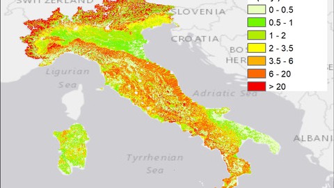
Soil erosion spatial modeling with RUSLE in ArcGIS software
Soil erosion spatial modeling with RUSLE in ArcGIS software, available at $64.99, has an average rating of 4.18, with 44 lectures, based on 102 reviews, and has 517 subscribers.
You will learn about Soil erosion RUSLE Modeling in ArcGIS supervised classification NDVI hydrologic analysis Model Builder spatial analysis Water erosion spatial modelling This course is ideal for individuals who are soil scientists or earth scientists or geography students or master students or ecologists or agricultural scientists or farmers or environmental science students or land management profession or GIS students It is particularly useful for soil scientists or earth scientists or geography students or master students or ecologists or agricultural scientists or farmers or environmental science students or land management profession or GIS students.
Enroll now: Soil erosion spatial modeling with RUSLE in ArcGIS software
Summary
Title: Soil erosion spatial modeling with RUSLE in ArcGIS software
Price: $64.99
Average Rating: 4.18
Number of Lectures: 44
Number of Published Lectures: 44
Number of Curriculum Items: 44
Number of Published Curriculum Objects: 44
Original Price: $27.99
Quality Status: approved
Status: Live
What You Will Learn
- Soil erosion
- RUSLE
- Modeling in ArcGIS
- supervised classification
- NDVI
- hydrologic analysis
- Model Builder
- spatial analysis
- Water erosion
- spatial modelling
Who Should Attend
- soil scientists
- earth scientists
- geography students
- master students
- ecologists
- agricultural scientists
- farmers
- environmental science students
- land management profession
- GIS students
Target Audiences
- soil scientists
- earth scientists
- geography students
- master students
- ecologists
- agricultural scientists
- farmers
- environmental science students
- land management profession
- GIS students
In this course, students will learn to model soil erosion of any given study area with the RUSLE (Revised Universal Soil Loss Equation) model in the most famous and widely used GIS software – ESRI ArcGIS. I will guide you through the course from what to start the RUSLE model and how to accomplish it and get a final soil erosion map of a study area.
The course is divided into 6 sections. The initial five sections refer to each parameter of the model – R (soil erosivity), K ( soil erodibility), LS (slope length), C ( land use and land cover), and P (crop management) factors and making final RUSLE modelling. No need for the field data. You just need the software and internet to execute the final map of soil erosion.
With this course, you will be able to make a spatial map of soil loss for any study area you want applying the most widely used soil erosion model in the world by soil scientists. Initial knowledge of ArcGIS and basic knowledge of geoinformatics are welcomed, but not necessary.
Besides just modelling, you will master such tools as supervised classification, NDVI map, hydrologic analysis, model builder, and some other useful tools, in case you are not familiar with them.
The course is easy to follow and accomplish. Mastering the modelling of water erosion is very helpful and in demand for specialists of a different kind, such as soil scientists, agricultural scientists, earth scientists, environmental scientists etc. Many course works as well as bachelor and master dissertations in universities include the research on soil erosion spatial modelling.
Course Curriculum
Chapter 1: Introduction
Lecture 1: Information about the course
Lecture 2: Start the RUSLE project
Chapter 2: Fundamental theory
Lecture 1: Soil
Lecture 2: Soil erosion
Lecture 3: Soil erosion prevention
Lecture 4: Different soil erosion models
Lecture 5: RUSLE model concept
Chapter 3: R factor (Rainfall erosivity)
Lecture 1: R factor. Theory
Lecture 2: Download precipitation data
Lecture 3: Global rainfall erosivity map from ESDAC
Lecture 4: Working with precipitation in NetCDF file of CRU
Lecture 5: Reproject monthly rainfall data
Lecture 6: R factor calculation with CRU monthly data
Lecture 7: R factor from EUJRE
Lecture 8: R factor for 30 meter pixel resolution
Chapter 4: K factor (Soil erodibility)
Lecture 1: K factor. Theory
Lecture 2: K factor calculation in Excel for dominant soil from FAO soil
Lecture 3: Fill attribute table with K factor
Lecture 4: Make K factor raster image
Lecture 5: K factor from soil database
Chapter 5: LS factor (Slope length)
Lecture 1: LS factor. Theory
Lecture 2: Download DEM
Lecture 3: Create Fill and flow direction for study area
Lecture 4: Flow accumulation
Lecture 5: Slope in radians
Lecture 6: LS factor map
Lecture 7: Correct LS values above 1000
Lecture 8: LS factor in SAGA GIS
Chapter 6: C factor (Land use and land cover)
Lecture 1: С factor. Theory
Lecture 2: Download Landsat images
Lecture 3: Composite bands
Lecture 4: Mosaic Landsat images
Lecture 5: NDVI map
Lecture 6: Making C factor map
Chapter 7: P factor (Conservation practice factor)
Lecture 1: P factor. Theory
Lecture 2: P factor table for slope and land cover
Lecture 3: Supervised classification of the study area in ArcGIS
Lecture 4: Reclasiffy slope and combine with classification map
Lecture 5: Assigning P factor values for classes in attribute table
Lecture 6: Extracting P values into seperate raster dataset and reprojecting
Chapter 8: Final water erosion modelling with RUSLE
Lecture 1: Making the final RUSLE model
Lecture 2: Resample into 100 meter resolution
Lecture 3: Making image representation for final map
Lecture 4: RUSLE model with LS factor from SAGA anf K factor from soil database
Instructors
-
GIS Lab
GIS
Rating Distribution
- 1 stars: 2 votes
- 2 stars: 3 votes
- 3 stars: 8 votes
- 4 stars: 40 votes
- 5 stars: 49 votes
Frequently Asked Questions
How long do I have access to the course materials?
You can view and review the lecture materials indefinitely, like an on-demand channel.
Can I take my courses with me wherever I go?
Definitely! If you have an internet connection, courses on Udemy are available on any device at any time. If you don’t have an internet connection, some instructors also let their students download course lectures. That’s up to the instructor though, so make sure you get on their good side!
You may also like
- Best Video Editing Courses to Learn in March 2025
- Best Music Production Courses to Learn in March 2025
- Best Animation Courses to Learn in March 2025
- Best Digital Illustration Courses to Learn in March 2025
- Best Renewable Energy Courses to Learn in March 2025
- Best Sustainable Living Courses to Learn in March 2025
- Best Ethical AI Courses to Learn in March 2025
- Best Cybersecurity Fundamentals Courses to Learn in March 2025
- Best Smart Home Technology Courses to Learn in March 2025
- Best Holistic Health Courses to Learn in March 2025
- Best Nutrition And Diet Planning Courses to Learn in March 2025
- Best Yoga Instruction Courses to Learn in March 2025
- Best Stress Management Courses to Learn in March 2025
- Best Mindfulness Meditation Courses to Learn in March 2025
- Best Life Coaching Courses to Learn in March 2025
- Best Career Development Courses to Learn in March 2025
- Best Relationship Building Courses to Learn in March 2025
- Best Parenting Skills Courses to Learn in March 2025
- Best Home Improvement Courses to Learn in March 2025
- Best Gardening Courses to Learn in March 2025


